
A brief history of Birmingham
HOW THE CITY GREW
Birmingham in Tudor Times
In Tudor times, John Leland, a contemporary historian, wrote:
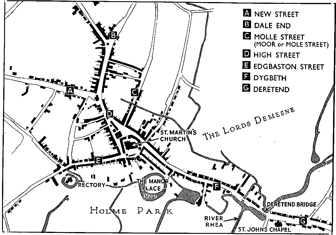
Birmingham in 1553
"The beauty of Bermingham, a good market town in the extreme parts of Warwickshire, is one street (Digbeth) going up alonge, almost from the left ripe (bank) of the brooke (Rea), up a meane hill (Deritend) by the length of a quarter of a mile. I saw but one Parrock Church (St. Martin’s) in the towne. There be many smiths in the towne, that use to make knives and all mannour of cutting tooles, and many lorimers that make bittes, and a great many naylors. Soe that a great part of the towne is maintained by smithes who have their iron and sea-cole out of Staffordshire."
Water. Mills were built on both banks of the Rea, and the water wheels turned the early machines used by the busy workmen of Digbeth, Deritend, and the environs of the Rea. But more important still, Birmingham was the only place in the district with a good supply of drinking water, which could provide for a growing population. The lack of natural communication is also a reason why Birmingham became so famous for making small things ("the toy shop of Europe" it was called), which required comparatively little transport.
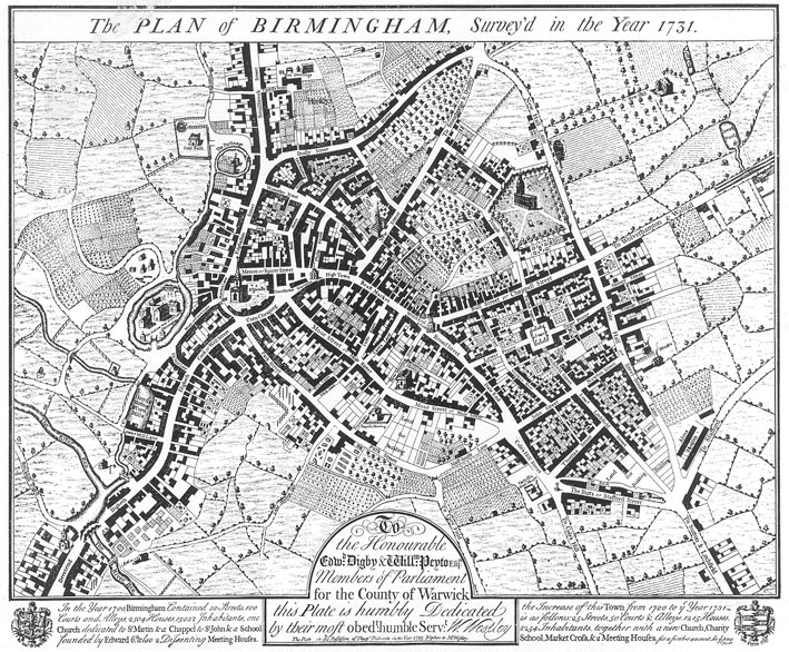
Plan of Birmingham, 173 I
Compare it with the map of 1553. Nearly two centuries have passed; the town of Birmingham has grown considerably, but is still clustered round the two highways and the numerous lanes and small streets, which run into them.Note the Manor House and its buildings still surrounded by the moat, while the parsonage of St. Martin’s, also moated, still remains untouched.
The market is easy to recognise with its High Cross plainly marked, while at the other end of the Beast Market is the Welsh Cross, which also served as a meeting room and in appearance was very similar to the High Cross.
St. Philip’s Church, standing in its spacious churchyard fringed with avenues of trees, is new, and is not yet surrounded by buildings.
The cherry orchards on one side of St. Philip’s Church should be noted. This site, part of which is occupied by Cherry Street to-day, later became a bowling green and open-air theatre for the strolling players who visited the town.
Notice, too, Steelhouse Lane, which was so called because of its houses where steel things were made. Other evidences of the growth of this industry are to be found in Careless’s Steel House in Coleshill Street. Birmingham was still a busy market town, surrounded by pleasant lands, fields and meadows, little bigger than the heart of the city is to-day.There are several Dissenters’ places of worship marked on this plan, such as the Old and New Meeting Houses and the Baptists’ Meeting House. These are evidence of the growing number of Nonconformists among the inhabitants of Birmingham.
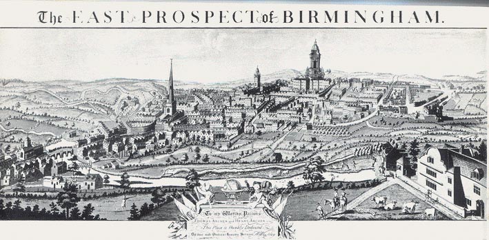
East Prospect of Birmingham, 1732
This is a general view of Birmingham, and brings to life the plan of 1731.
The River Rea, banked by pleasant undulating meadows, is seen in the foreground of the picture, with the cattle, sheep and horses of the neighbouring farmers grazing there. Across the river at Deritend the old bridge can be seen, with St. John’s Chapel close by. Behind a stretch well-wooded meadows and fields which in medieval days formed the Park of the Lords of the Manor. The Manor House and its buildings can be seen with the moat around it still preserved. Closely encircling the church of St. Martin’s, whose tall spire makes it easily recognisable, are the homes and workshops of the tanners, smiths, nailers, lorimers and tradesmen of the neighbourhood. The Tower of the Free Grammar School in New Street rises above the other buildings around, while to the right of it is the newly completed church of St. Philip,
Below St. Philip’s Church are some gardens which may have been the first allotments, always so popular in Birmingham.
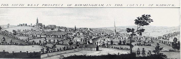
South-west Prospect of Birmingham, 1732
This gives you a view of Birmingham from the opposite side of the River Rea to the previous one.You can see the moated Manor House and parsonage very clearly in the foreground amid the well-wooded Holme Park. The thoroughfare stretching away to the right is Digbeth and Deritend, behind which lie wide fields and green meadows on both sides. The gabled houses visible below St. Martin's Church, near the parsonage, stand at the beginning of Smallbrook Street. The imposing row of tall houses in Temple Row to the right of St. Philip’s Church must be the "buildings in elegant taste" referred to by Hutton. St. Philip’s Church dominates the left part of the picture, with New Hall, a spacious house on the extreme left, approached from Newhall Lane by a long avenue of trees.
Birmingham in 1886
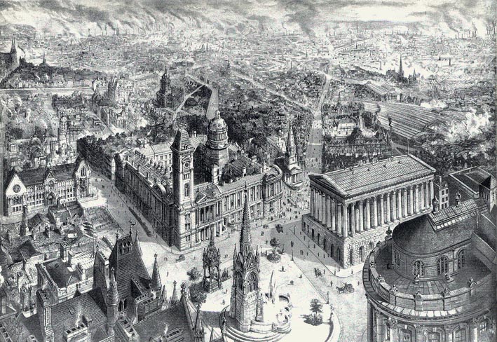
You will be able to identify most of the prominent buildings in this picture of Birmingham in 1886, taken from "The Graphic". Christ Church, at the top of New Street, has, of course, disappeared. Notice smoke pours from hundreds of factory chimneys, unhealthy and wasteful though it was. Such chimneys were the chief feature of the whole landscape for many miles to the north and north-west and gave the district its name of The Black Country.
Birmingham was granted city status 3 years later in January 1889
![]()
![]()